Forces aligning to rezone north, northeast Minneapolis riverfront
June 2011
Two separate efforts — the Above the Falls Plan and the Minneapolis Riverfront Development Initiative — are underway to redesign the Minneapolis riverfront above St. Anthony Falls. How they come together will greatly influence what the north and northeast Minneapolis riverfront will look like a generation from now.
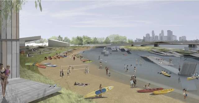
The MRDI concept envisions recreating the pre-existing Hall's Island alongside the Scherer Brothers site, which creates a new cove and swimming beach. (Image: Tom Leader Studio)
The Above the Falls Plan
In 1999, the City of Minneapolis and a wide variety of partners (including FMR) crafted and adopted the Above the Falls Master Plan. The plan sought to expand much of the citys success and momentum in the Central Riverfront into the predominantly industrial area north of Plymouth Avenue. It calls for a continuous riverfront park and trail system on both sides of the river and a shift over time from primarily industrial to commercial, retail, and especially residential usage.
Since the plan's passage, there have been many successes, including the renovated Grain Belt Brewery art and office complex, the new headquarters for the Minneapolis Park & Recreation Board as well as Coloplast company, extended parkways and the park taking shape on the former Scherer Brothers Lumber Co. site at Plymouth. However, one critical piece of the Above the Falls Master Plan was never acted upon: there was never a coordinated rezoning to conform with the plans proposed new land uses. Until now.
Rezoning and Upper Harbor Terminal
The Above the Falls Policy Review and Implementation Study sets the stage to rezone properties in the area within a few blocks of the river from Plymouth Avenue to the Minneapolis city limits. The citys planning department has brought in private consultants to answer core questions about market conditions and the suitability and marketability of various development types on land along the river.
The study thus far shows new industrial uses are generally better suited to the west side of the river. New commercial office uses are best suited just north of downtown, and along Dowling Avenue on the west side of the river. Residential uses are best suited mainly on the east side of the river but could be viable on the west side with some heavier upfront investment by the city.
The real issue is how city leaders will respond to this information. One of the most important long-range choices we have to make is how to deal with the Upper Harbor Terminal, said River Corridor Program Director Irene Jones.
The very large city-owned property known as Upper Harbor Terminal sits between roughly 33rd and 40th Avenues North on the rivers west bank, a few blocks east of I-94. Seven years ago, FMR partnered with the City of Minneapolis to study potential ways to reuse the site as riverfront parkland and a new residential neighborhood with limited commercial uses. The number of users of the port has dwindled substantially in recent years, and it may not make economic sense for the port to remain open. Creating a park on the site would in turn act as a catalyst to spur nearby re-development and new economic growth.
Intriguingly, the study the city has undertaken so far shows the area could be viable for new residential and to a lesser extent office development but with a major caveat. Residential in that area would only be viable provided the City invests meaningfully in the sort of place-making amenities like larger riverfront parks that would open up the area to marketable new development. The need for parks and infrastructure firstto spur new development, was also the conclusion of the 2004 Upper Harbor Terminal study.
Normally, encouraging that sort of redevelopment often requires substantial land assembly and other costs, which can be very cumbersome and costly for a local government. The advantage of the 48-acre Upper Harbor Terminal site is that the city already the land, eliminating one substantial barrier to changing land use.
There's really a lot of potential at the Upper Harbor Terminal site that we need to be careful not to squander, Jones said. With the funds available through the Legacy Amendment and other sources, we have a real opportunity to shape a needed permanent park amenity in this area that in addition to adding a key riverfront park to the northside could help spur new housing and commercial growth in the surrounding area.
The in-depth research the city has undertaken to date — the product of economic analysis, surveys and personal interviews — will continue to inform the City's final approach to the issue. The other major effort that promises to change the face of the Above the Falls area is the MRDI.
Minneapolis Riverfront Development Initiative
The Minneapolis Riverfront Development Initiative (MRDI) is an exercise to bring fresh thinking and vision to the task of reinventing the Minneapolis riverfront above St. Anthony Falls. Earlier this year, the Minneapolis Park & Recreation Board held a Riverfront Design Competition to solicit ideas for the upper riverfront, and the winning team was selected to develop their concepts (40MB) more fully, with the idea of implementing one or more of them.
The MRDI, has proposed a variety of intriguing concepts such as a land bridge over I-94 to connect the riverfront to Farview Park on the city's North Side, a restored Halls Island, along with a new cove and swimming beach, as part of a new park at the Scherer Brothers site, and the restoration of a long-forgotten riverfront wetlands just northwest of the Lowry Bridge.
When it comes to the future of the Upper Harbor Terminal, the proposal envisions a "greening," rather than a riverfront park per se. The MRDI "RiverFIRST" proposal promotes a "Green Port," which would consolidate port uses on a smaller footprint, allow expanded riverfront access, better treat stormwater, and provide land for a potential new green economy corporate headquarters.
For now, the MRDI presents only concepts; more public process would be required to bring any of them to a more final form.
"Somewhere between these parallel efforts, the Above the Falls study and MRDI, big changes seem likely for this section of the river corridor sooner rather than later," said Jones.
Hopefully, we can have a good conversation about the Above the Falls area without substantially stepping back from the commitment to riverfront parkland envisioned in the plan.