St. Paul celebrates a milestone in the evolution of its Mississippi River corridor
Last week, St. Paul threw a party to celebrate the biggest milestone in over a century in the evolution of its 17-mile-long riverfront. After a year of research, planning and public discussion, the City of Saint Paul unveiled a vision for the future of the Mississippi River in the city. Arguably, the creation of the plan for the citys riverfront was the single most important step for the riverfront since Horace Cleveland inspired the protection of the system in the late 1800s.
This plan really raises the vision for a key part of the Mississippi to a whole new level, and challenges us to ensure the Mississippi lives up to its full potential, said FMR Executive Director Whitney Clark.
St. Pauls riverfront is expansive and diverse. It covers roughly a quarter of the Mississippi River National Park that runs through the Twin Cities. It includes secluded natural areas like Lilydale and Crosby Parks, along with the highly urbanized riverfront downtown, at Harriet Island and the West Side Flats. It includes the deep gorge it shares with Minneapolis, and the broad basin and lowlands through the West Side Flats and Pigs Eye Lake area, where the City traces its earliest origins.

Shepard Road: A redesigned Shepard Road through south Highland Park would slow traffic with elements such as a lower speed limit, plantings, and well-demarcated pedestrian crossings.
For several decades now, the city has methodically reoriented itself toward the riverfront as a cultural, ecological, recreational, economic and scenic resource, but never before has the city produced a cohesive vision of enhancement and stewardship for the river corridor as a whole.
The plan builds on basic concepts established a few years ago in the Citys Great River Park Framework. The basis of that framework was to create a river corridor that was more natural, more urban and more connected.
Great River Passage: a brief overview
Trying to understand and propose improvements to 17 miles of river is assuredly a challenging task. Trying to summarize that work is even more difficult. That said, here are a few of the highlights:
- At Hidden Falls Park, Hidden Falls itself and the surrounding creek will be restored, and integrated with the redevelopment of the Ford Motor Company site. Several acres of riverfront land currently owned by Ford are anticipated to be added to the northern end of the park.
- At Crosby Park, a new gathering center will be built at Watergate Marina. The Center will serve as a year-round hub for recreation, with an equipment rental space, interpretive center and, possibly, a restaurant space akin to the Sea Salt restaurant housed in Minnehaha Park in Minneapolis.
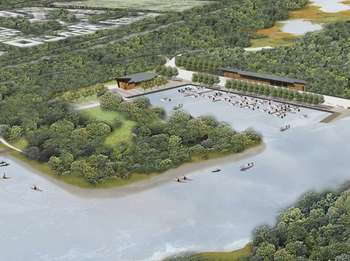
A new gathering center would be built at Watergate Marina at Crosby Regional Park. The center would provide a year-round recreational hub, equipment rental, interpretive space, and potential private restaurant, akin to Sea Salt in Minnehaha Park in Minneapolis.
- Randolph Avenue will be strengthened between West 7th Street east to the river to provide new sidewalks and redevelopment connecting the refurbished Schmidt Brewery area with the old power plant known as Island Station. Down at the river, the refurbished plantwill serve as a potential new home for the National Park Service, environmental organizations and provide a separate landing area for canoeists, along with an ice-climbing wall and other active recreation opportunities.
- Lilydale Park will see many of the improvements outlined in the recently adopted Lilydale Park Master Plan, including a new picnic area in which is expected to be built over the coming year alongside Pickerel Lake, as well as a rerouted Lilydale Road, dog park and extensive ecological restoration and management.
- In Downtown St. Paul, a new river balcony is being proposed for the riverfront side of downtown buildings, providing easy views and connections to view the riverfront. New connections will facilitate the movement from bridges to riverfront trails. Broadway Street will connect Lowertown with the river, and a new bridge at the Bruce Vento Sanctuary will help complete several walking circuits to activate this portion of the riverfront. Lower Landing Park may host a new skate park or dog park.
- On the West Side Flats, the existing riverfront promenade will be complemented by alternating green park fingers connecting deeper into the West Side, interspersed with new structures up near the promenade that would include active uses such as restaurants fronting the promenade.
- In the greater West Side, new trails will fill in a key gap, and at long last provide off-road trails from one end of the river corridor to the other. New trails along Plato Boulevard, the riverfront north of Holman Field, Ohio Street and elsewhere will knit together the trail network and connect it to South St. Pauls extensive riverfront trail system.
- Access to Pigs Eye Regional Park will at long last be made real, with a new connection extending from Warner Road near Childs Road, and continuing south to the north end of Pigs Eye Lake. A new parking area, small boat launch, trails and wildlife viewing areas will finally open up this key park space to the public. Connections may eventually be made from the park toward the east, and over or under US highway 61.
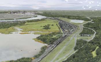
Long isolated by lack of road and trail access, improvements Pigs Eye Regional Park would finally open the area, including Pig's Eye Lake, up to easy public access.
- The Highwood Bluffs will for the first time see an existing off-road trail woven along the bluffside, connecting areas laterally along the river corridor. In the far southeast corner of the city, a renewed Fish Creek park will complement intensive efforts in Maplewood to develop a greenway along Fish Creek.
And with all of these changes in the pipeline, St. Paul also has taken time to re-evaluate the name of the corridor and how its many parts are conveyed to the public. What has been known until now as the Great River Park will now be known as the Great River Passage. Newly designed coordinated wayfinding signs will guide users to and through the length of the corridor.
The party and rollout of the plan is just a beginning; the plan will now go through public hearings at the Citys Parks Commission and Planning Commission, and ultimately is expected to be approved by the Saint Paul City Council early next year.
In the meantime, more information can be found online at the Great River Park website, and from FMR River Planner Bob Spaulding at 651-222-2193 x29.