Whose view? From where? November 2009
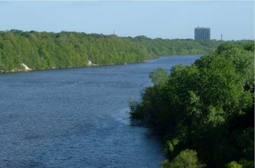
FMR has a presentation we sometimes show other communities, and in it, we show a picture similar to this (above) and ask people where they think it is. Frequently, audience members respond by guessing places like Red Wing, or maybe Hastings.
When we reveal that it is in fact looking down the border between the two central cities the very heart of the Metropolitan area, many are amazed. More amazing still is that hundreds of homes and a major University campus dot this section of the river, and are basically invisible in this view.
Click the image for a better view. [PDF, 188k]
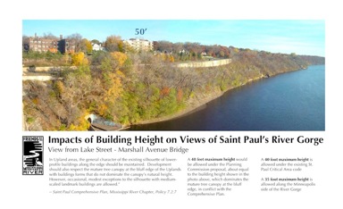
St. Paul is considering changes to its Mississippi River Critical Area zoning in the coming months. As St. Paul considers these changes, we think it is important that the City retain their current 40 foot height limit along this section of the river. Such a height limit is already higher than their neighbors across the river in Minneapolis, where 35 feet is the standard. And moreover, 40 feet is the height at which structures would begin to break through the treeline, as demonstrated by the graphic at right, which is the height standard set in the Citys Comprehensive Plan.
Astutely, Eric Otterness submitted this guess:
"I believe this picture is taken from the Lake Street Bridge looking south at the St Paul side of the gorge. The picture is carefully framed to leave out as many man made things as possible. The water is high and the leaves are full to hide the buildings along the river road. You can just make out two green bouys and possibly a barge has just gone through going upstream because of the visible waves that may be it's stern wake."
Astute, because indeed, we did crop out a few key human-made landmarks. Most notably, we cropped out the 23-story residential high-rise that stands at the end of the Ford Bridge 740 Mississippi River Boulevard. You can see an image of the view with the high-rise below; it projects a different much more urban sensibility. The camera angle also did not incude some of the lower-rise buildings next to St. Paul side of the Lake Street Marshall Avenue Bridge.
Brian Nerbonne correctly wrote,
"This month's location is looking downstream from the Lake St. bridge, a scene I see everyday as I go to work. The Mississippi River at this location was once a raging rapids of continental significance for fish populations of the river, but for close to the last century has been impounded by the Ford Dam and hosts only a shell of its former fauna under a layer of sand and semi-stangnant water."
About Whose view? From where?
Each month in this section, we feature a photo somewhere along the river corridor in the Twin Cities that is in some way significant or important or just plain scenic. Individuals may then e-mail us and identify the view and explain why they believe it is significant to the community or important to them personally. Well publish some of your responses in the next issue of Mississippi Messages, where we will also reveal the correct answer.
To submit your guess and response, e-mail Bob Spaulding, River Advocate, through our contact form. The respondent to provide the first correct identification of the view and hopefully some interesting thoughts about its significance will receive a valuable prize for their effort. All entries must be received by the first day of the following month for consideration.